
Landscapes in Europe

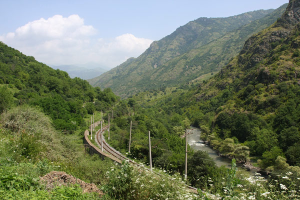
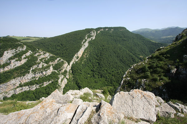
The Debed river, that cuts through Armenia and ends in Georgia, has carved the Debed Canyon, one of Armenia's most beautiful areas. The main road to Georgia follows the river at the bottom of the canyon, offering amazing view at every turn. The slopes are mostly covered in woods with a few towns and villages here and there. There are two World-Heritage-listed monasteries in the region, Sanahin and Haghpat, along with less famous (but not less interesting) churches and chapels - and the usual bleak reminders from Soviet time, including a copper mine at Alaverdi.
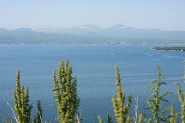
Lake Sevan is Armenia's largest lake and is located at an altitude of 1,900 m - which should make it the second highest commercially navigable lake after Titicaca (3,811 m). It is deep blue and fringed by green fields, abandoned Soviet buildings, local villages and ancient churches - and popular for holidaying Armenians. In pre-Soviet times, the water level was 20 m higher with a surface 50% larger than today, but a Soviet-engineered irrigation project (similar to the one that made the Aral disaster) shrunk the lake and turned Sevan Island into a peninsula. Recent attempts have been made to save the delicate ecosystem by raising the water level to its original level, but it will be interesting to see how far they will get since farmers, resorts and even the president's summerhouse (behind Savanavank) are located right at present water level.
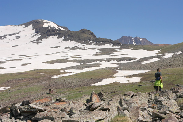
Since imposing Mt. Ararat (5,137 m) rises in the horizon behind the Turkish border, Armenia's highest mountain is the beautiful little sister Mt. Aragats (4,090 m). It is a volcano with four peaks and the beautiful green foothills are dotted with tent camps of Yezidi Kurd herders along with their livestock. An old Soviet observatory Byurakan is located at 3,200 m and is the reason why there is a road all the way up to the alpine Lake Kari that forms during spring. The southern peak can be reached by scrambling (not just trekking) while the northern peak (the highest) needs gear to be summited.
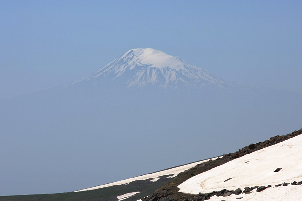
Yes, we are well aware that Mt. Ararat (5,137 m) is located in Turkey and so is the Armenian people, but nevertheless the Armenians consider it as one of their own. The picturesque cone of Mt. Ararat (and Lesser Ararat) is always something people look for whether it is from their apartment window in Yerevan, from the top of the Cascade (also in Yerevan), as a gorgeous backdrop for the iconic Khor Virap monastery or from the slopes of Mt. Aragats (4,090 m), the highest mountain in Armenia. So if the visibility is good, do as the Armenians and take in the splendid view.
© John Smith
Right outside Shushi town, the meadow breaks off into a canyon. There are beautiful views over much of the neighbouring hills, Stepanakert below and central Artsakh. If the summer heat is burning hot, it is a great place to catch a fresh breeze while you enjoy your lunch pack under a shady tree.
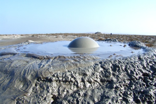
A short day trip south of the Azerbaijani capital, Baku, sit two rather different attractions. One of the particularly odd natural phenomenon is the mud volcanoes. With the majority of Azerbaijan's nearly 700 mud volcanoes (over half the number in the world), Gobostan is a great place to see the bubble-bubble action. Although not for bathing, simply wandering around the other-worldly landscape is worth the trip in itself. But, sharing the site is the UNSECO listed Rock Art Cultural Landscape. On the plateau overlooking the mud volcanoes are some 4,000 rock carvings covering 40,000 yeas of rock art. Gobostan is a rare chance to see both natural and man made wonders with having to wander too far.
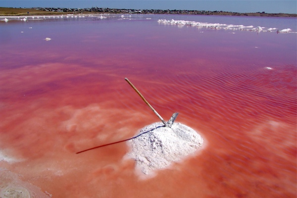
No trick photography nor photoshop magic, the red lakes of Masazir are an odd site to behold. Although not unique in the world, the colour salt lakes make for a interesting day trip on their own (from Baku) or as part of a larger area exploration. The reason for the colour is due to a microscopic organisms that thrives on the extreme salt nature of the lake. Best seen on sunny days with high humidity in the mid afternoon, the colours can be quite stunning. As an extra souvenir, travellers can even buy some of the processed salt from the village as it's production is a major economic staple for the otherwise uninteresting village of Masazir.
Mt Vitosha (2290m) is visible from all over Sofia. At the lower slopes you find some of the poshest neighbourhoods of Sofia, but higher up you find fine forest, hiking trails and ski slopes. One of the more accessible trail heads is the at Boyana village close to the Boyana church, which is an UNESCO World Heritage site. From here you follow several trails, one to Boyana waterfall and lake (about 4 hours return).
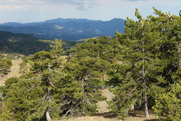
The highest mountain on Cyprus is Mount Olympus - what else could it be called. It's a pine tree covered peak, which from the distance easily blends in with other peaks in the Troodos Mountians. You can drive all the way up the ski resort (yes, they have chairlifts and runs) right below the top at 1,952 m, which is unfortunately occupied by the military. But the views over lowland Cyprus are spectacular.
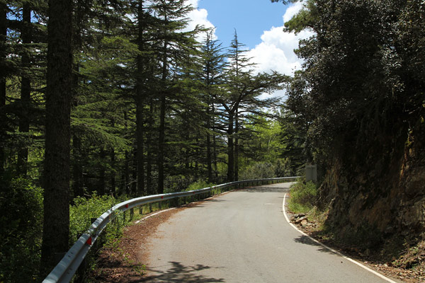
The Troodos Mountains have some world class mountain roads. Narrow winding roads which zigzag through cedar tree covered mountain slopes. Here and there the forest opens up for amazing panoramic views over the Troodos Mountains and lowland Cyprus at the coast. The most popular routes are sealed, but drive slowly and carefully since pretty much every turn are blind and there are a plenty of small rock falls.